Voëlklip - Bird Rock Beach, Hermanus. What's in a name?
“The origin of the name of this suburb of Greater Hermanus seems to be obvious,” wrote Dr Robin Lee of the Hermanus History Society: “There’s this great big rock about 150 metres off one of the most popular beaches along the coast. In the past this rock was covered with thousands of sea birds (mainly cormorants), busy with their own affairs and leaving layers of white droppings….
What more obvious than to name the adjacent land after this iconic rock?”
“In 1897 Agnes Stroud [ed – daughter of land baron Duncan McFarlane] had a portion of Mosselrivier Farm surveyed separately for residential development and sold the land to the Mossel River Estate Company Ltd. This company was responsible for developing the Village of Mossel River. The word “Voelklip” does not appear anywhere [in this] history.”
“The company prepared a grid pattern of roads and avenues and, unlike Hermanuspietersfontein and Poole’s Bay the streets and avenues were numbered, not named. The township comprised First to Seventeenth Streets and First to Eleventh Avenues. Individual plots were sold and the new owners engaged contractors to build to their specifications. In the early years, there were few regulations governing the construction of the houses, and most were best described as sea side cottages.
The plan headed ‘Mossel River Sea Side Township’ from 1918 shows the grid pattern and that only plots near the sea had been sold. Also, it shows a planned railway through the township, presumably going on to Stanford and beyond. It is obvious that Sir William Hoy’s intervention to stop the railway coming to Hermanus made sure that the Mossel River railway was never built.”
Many houses were being built here between 1920 and 1939. “During this time the informal name of Voëlklip began to be used. The preference for Voëlklip over Mossel River possibly reflected the nature of the population moving into the township. They were mainly families building holiday homes, with little or no settled connection with historic Hermanus and its names. They were oriented to the beaches and the sea and took more easily to a name that reflected a seaside suburb… The Voëlklip was… clearly visible from the cliffs and especially from the two main beaches – Kammabaai and Voëlklip Beach itself.”
Source: Edited from Dr Robin Lee, Hermanus History Society
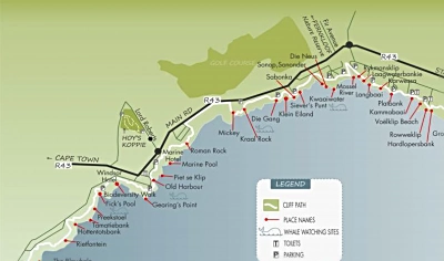
The map below shows landmarks and sites along the 12 km of cliff path. Source: Hermanus History Society

